Jekyll2026-04-10T12:35:26+00:00https://carolinemusyoka.github.io/feed.xmlCarol MusyokaTravel, photography, and stories from around the world.Carol Musyokacarolmusyoka127@gmail.com24 Hours in Stone Town2026-03-15T00:00:00+00:002026-03-15T00:00:00+00:00https://carolinemusyoka.github.io/24-hours-in-stone-townStone Town is one of those places that rewards the curious. It’s not a city you experience from a checklist — it’s a city you absorb by walking, by turning into alleys you weren’t planning to enter, by sitting in courtyards and watching life happen around carved doorways and coral-stone walls.
Twenty-four hours isn’t enough, but it’s enough to fall in love with it.
]]>Carol MusyokaNairobi to Mai Mahiu, Suswa Road and Back via Ngong2026-03-14T00:00:00+00:002026-03-14T00:00:00+00:00https://carolinemusyoka.github.io/suswa-circuitI had a plan for this drive. It involved a nice spot well before Mai Mahiu, a rough road about 10 kilometres off the main highway. I did not make it. The road asked too much of the car and I turned back.
So I found myself in Mai Mahiu with the afternoon still ahead of me and no particular agenda. That’s when I came across Ubuntu Life.
It started, as the story goes, with nine mothers. Their children — all with special needs — had been enrolled at a new care centre in town, and suddenly these women had time on their hands for the first time in years. They went to the founders and said: now that our kids are out of the house, can you help us do something productive with our time? The answer was a room, three manual Singer sewing machines, and a question about what to make. Shopping bags, coffee sleeves, bandanas, coasters. That was 2009.
By the time I visited, that 15x15 foot room had become an 11-acre campus. Over 400 Maker Mums now produce bags, shoes, and beaded bracelets, the bracelets made in collaboration with womenn sold to buyers across Kenya and internationally. The Children’s Wellness Centre on the same campus is the only facility in the Rift Valley region where children with special needs can receive medical care, therapy, and education under one roof.
I had a snack at the Ubuntu Café, an open-concept kitchen where the food comes largely from the campus farm. Then it rained.
When the rain cleared, I took the Suswa road north toward Ngong. It’s a quieter route than most people use, largely empty. There is a really nice view point somewhere on the road, it’s unmarked so it’s just something you will def notice.
I marked it on my maps and kept driving. Ngong. Then Nairobi.
Not the drive I planned. A better one.
One more thing about Ubuntu Life — the stitch.
Every canvas and leather product they make has a small diagonal tab stitched at an angle. I didn’t know what it meant when I saw it. Turns out it’s not decorative.
Mai Mahiu sits at 1° South, 36° East. That diagonal stitch is set at exactly 36 degrees, the longitude of the town where every bag, shoe, and bracelet is made. It’s the GPS coordinates of the Maker Studio, embedded permanently into every product that leaves it.
It also represents the topography of the Great Rift Valley itself, the cuts and scars in the earth from tectonic shifts and geothermal activity. The same landscape you drove through to get here.
The beads on the bracelets are a nod to the Maasai, who use glass beads in everything from clothing to ceremony. The brand’s blue and orange palette comes from the paint colour on rural Kenyan homesteads (blue) and the red of Kenyan soil (orange). And on the sole of every Lamu Mule and Afridille, there’s a world map — with a heart etched over Africa, marking exactly where the shoes were made.
Every detail is intentional. That’s the thing about Ubuntu Life, once you know what you’re looking at, you can’t unsee it.
]]>Carol MusyokaShades of Blue Down South2026-03-13T00:00:00+00:002026-03-13T00:00:00+00:00https://carolinemusyoka.github.io/shades-of-blue-down-southThere’s a point somewhere past Mtito Andei (every place after that is ‘The Coast’ to me) where the landscape shifts. The red earth gives way to scrubland, then palm trees start appearing some kilometers later, and you can almost smell the salt before you see the water. That’s when you know you’re close.
I’d been planning this trip for weeks but it came together fast, fuel up in Nairobi, hit the road early, catch the sunrise somewhere after Emali, and don’t stop until the ocean.
The Drive Down
Left Nairobi before sunrise. The Mombasa highway is smooth and fast if you beat the truck convoys at that hour. The first stop was Java House in Voi where I had an iced coffee, stretch the legs, bathroom break, check the car. I tend to do my stops somewhere closer to my destination ish so that I can convince myself I’m closer, lol. Voi sits roughly halfway and the Java there has become a ritual stop for anyone doing this drive. Twenty minutes and you’re back on the road feeling human again.
The last stretch is the best part. Once you pass Mombasa and hit the Dongo Kundu Bypass, the drive transforms completely. This bridge is an engineering marvel, soaring over the creek, mangroves below, the Indian Ocean opening up ahead. It cuts out the old Likoni ferry queue entirely and shaves a good hour off the trip. You can do a couple of stops on the way. Such a nice drive especially if you want to send it.
Boxo Diani & Lala Galu
Home for the trip was Boxo Diani, tucked right next to Lala Galu , they’re run by the same company and share that stretch of beachfront. Boxo is the newer, more vibrant side. Think container-style rooms, a pool that catches the afternoon sun, and a DJ most evenings that sets the mood without overwhelming conversation.
The beach is literally a stone’s throw away. Step off the property, cross a strip of sand, and you’re in the Indian Ocean. The water here is that impossible turquoise that looks photoshopped but isn’t.
Sunnyside Up Restaurant
The restaurant inside Lala Galu, Sunnyside Up ,became our default spot for most of my meals. The menu leans modern coastal: grilled seafood, burgers, fresh salads, and excellent breakfast platters. For drinks, the passion fruit mojitos are dangerous in the best way, and they do a proper cold Tusker (I have a feeling, this was a sober trip for me coz, solo, driving…lot’s of excuses I know). The frozen margaritas by the pool became a daily ritual.
Breakfast here is the move , eggs however you want them, fresh tropical fruit, pancakes, and strong Kenyan coffee. Sit outside and you’re eating with ocean breeze and palm tree shade.
Galleries in Diani
Diani has a handful of art galleries worth visiting if you need a break from the sand:
Diani Beach Art Gallery — Open daily 9am–6pm. Local Kenyan artists, vibrant coastal paintings, and handmade jewellery. The kind of place where you walk in for five minutes and leave an hour later.
Nomad Beach Gallery — Open Wed–Mon 9am–7pm. On the beach strip near Nomad restaurant. Photography-heavy, with rotating exhibitions from Kenyan and Tanzanian photographers.
Art at Sea — Open Fri–Sun 11am–6pm. Small but thoughtful gallery space above a beachfront café. Mostly prints and mixed media. The rooftop is worth it for the view alone.
The Gallery Diani — Open daily 10am–6pm. More commercial but good for picking up framed prints and locally made homeware. Nice gift shopping.
The Wasini Day Trip
The highlight of the whole trip. Wasini Island is about less than an hour’s drive south of Diani, then a short boat ride across the channel. The booking process is simple. I hadn’t booked prior so I had to first hope they had any boats available. They have agents who can help you book one so no need to worry. All this was at the KWS Kisite Mpunguti Park. I paid 800 to the guide, booked the park fees through the KWS website. Usually it’s around KES 4,500 per person, all-inclusive: ride from ukunda, boat, lunch, snorkelling, and the dolphin excursion.
Dolphins
We left Shimoni early morning and within twenty minutes we were surrounded by bottlenose dolphins. The boat captain knows their routes. He cut the engine and we just drifted alongside them , dorsal fins breaking the surface, the occasional full leap. Unreal.
The Low-Tide Island
After dolphins, the boat took us to a sandbar island that only appears at low tide. Crystal-clear water barely knee-deep stretching in every direction, with a small patch of white sand in the middle of the ocean.
The Island Village
Lunch was served in a local village on Wasini Island — a women’s cooperative that prepares seafood spreads for visiting groups. We sat in what looked somewhat like the dining halls in highscool..but open concept. You have a really nice 180 deg view of the ocean, the floor of an open-air coral house eating crab, octopus, grilled fish, coconut rice, and fresh mango. No menu, just everything they caught that morning, prepared the way it’s been done here for generations. I really enjoyed the seaweed, that was my highlight. If you get to read reviews on google maps you might be skeptcal about trying the food, so uhmm, just go with your gut, no pun intended.
Diani isn’t just a beach. It’s the drive down, the bypass over the creek, the art in unexpected places, the seafood on a stranger’s floor, the dolphins at dawn, and a sandbar that vanishes with the tide.
Book of the trip. Donezo.
]]>Carol MusyokaExploring Kanunga2026-03-12T00:00:00+00:002026-03-12T00:00:00+00:00https://carolinemusyoka.github.io/exploring-kanungaKanunga is one of those places that Nairobians drive past on the way to somewhere else without realising what they’re missing. Tucked in the green highlands of Gatundu, barely an hour from the city, it’s home to Ndakaini Dam — the massive reservoir that supplies most of Nairobi’s water — and a waterfall that almost nobody talks about.
I came here on a Saturday with no real plan. Just a vague tip from a friend who said the dam was worth seeing. He was right.
Ndakaini Dam
The dam sits in a valley surrounded by tea estates and patches of indigenous forest. It’s enormous — one of the largest in Kenya — but it feels surprisingly serene. No crowds, no signage, no tourist infrastructure. Just water, hills, and silence.
I walked along the edge for about half an hour, watching the light change over the water. The colour shifts from grey-green in the morning haze to a deep teal by midday. There were a few fishermen in the distance but otherwise I had the whole place to myself.
The Lakeside Resort
Before heading to the waterfall, we stopped at a small resort near the dam — one of those quiet places that clearly thrives on weekend day-trippers from Nairobi. Simple gardens, a menu of stews and chapati, and a view over the water that makes you forget you’re barely an hour from Westlands.
The Waterfall
The falls are the reward. A short walk from the road through farmland, then a trail that drops into forest. You hear the water before you see it. The falls themselves aren’t the tallest in Kenya, but they’re powerful — the kind that throw mist twenty metres into the air and make the ground tremble under your feet.
The spray soaks everything within minutes. I had my camera in a plastic bag for most of the time, shooting in quick bursts between wrapping it back up. The rocks around the base are covered in bright green moss and the light filters through the canopy above in shafts.
Kanunga is proof that some of the best places in Kenya are the ones that haven’t made it onto anyone’s must-see list yet.
If you’re looking for a day trip from Nairobi that doesn’t involve game parks or the Rift Valley, this is it. Leave early, take the Thika road, turn off at Gatundu, and keep driving until the tea fields start. You won’t regret it.
]]>Carol MusyokaNairobi to Kakuzi2026-03-10T00:00:00+00:002026-03-10T00:00:00+00:00https://carolinemusyoka.github.io/nairobi-to-kakuziThe Nairobi–Kakuzi drive is not one that most people make for its own sake. You take the Thika Superhighway north, clear the city in about an hour, and somewhere past Kenol the road enters Kakuzi territory and stays there for the next twenty-odd minutes. Timber plantation on both sides, red soil roads cutting into the orchards, the flat-topped shapes of avocado trees in rows on rolling ground. Kenya has plenty of scenery. This is a different kind of it — working farmland on a scale that’s hard to grasp until you’ve driven through it.
The farm has been here since 1906, when a man called Donald Seth-Smith arrived from Oxford and bought land in Makuyu. Coffee and sisal first. Then avocados, when the coffee got sick in the eighties and they needed to diversify. Then macadamia. Now also blueberries, commercial forestry, and a cattle herd that grazes open grassland between the timber blocks. The whole operation spans 213 km² and is listed on both the Nairobi and London Stock Exchange.
The Farm Walk
This is the main reason to come, and it has to be arranged in advance. You contact Kakuzi directly through their website, request a visit, and they assign someone to take you around. It is not a tourist excursion with a script — it’s a working farm that allows visitors in when it suits them.
The avocado operation is the scale-setter. Kakuzi produces both Hass and Pinkaton varieties, graded by hand, packed in 4kg and 10kg cartons, cold-stored, and shipped to Europe with an average farm-to-market time of 30 days. The pack house during season is full operation — colour-coded crates, sorting lines, cold rooms, the whole chain visible from one end to the other.
The macadamia groves are quieter and better to walk. Mature trees with yellow feathery flowers hanging down, clusters of brown fruits in the canopy. The processing factory next to it is the part that surprises people — dehusking machines, sorting belts, metal detectors, cold storage, packing lines running flat out during harvest. A lot of work goes into getting a macadamia nut into a bag, and you understand the price better after seeing it.
The cattle are Boran — a hardy East African breed, 100% grass-fed, no inputs beyond tick control and early worming. They roam open grassland between the timber plantations. The herd peaked at 7,500 in the 1980s. Smaller now, but the quality is what drives the Boran Barn down the road.
Best time to visit: avocado harvest runs March to October, macadamia in two phases — March to May, and September to October. Outside these windows you’ll still see the orchards and factory, but the operation is quieter.
The Sagana River
If you’re continuing north toward Nyeri or just stretching the drive, the Sagana River crossing a few kilometres past Makuyu is worth a brief stop. The Sagana is the upper Tana — it drains both the Aberdares and the slopes of Mt Kenya and by the time it reaches the A2 bridge it’s moving with intent. The water is broad and brown, the banks are forested, and on a clear day the blue ridge of the Aberdares is visible upstream. It takes five minutes and costs nothing. Pull well off the road first — the bridge is narrow and trucks are frequent.
Boran Barn
No booking required. The barn is open to anyone, and the beef is from the same Boran cattle you may have just seen in the fields. Slow-roasted over charcoal or wood fire, the kind of nyama choma that has a point of difference because the animal was raised fifty metres away on grass. Kachumbari and avocado on the side. A coffee shop with Kakuzi products. A farm market with fresh produce. And a shop where you can buy macadamia nuts — honey-coated, plain, or pressed into cooking oil — and biltong.
It’s a good-sized space, calm, child-friendly, and the kind of place that feels nothing like Nairobi even though you left less than two hours ago.
Buy the macadamia. You’ll wish you’d bought more on the drive home.
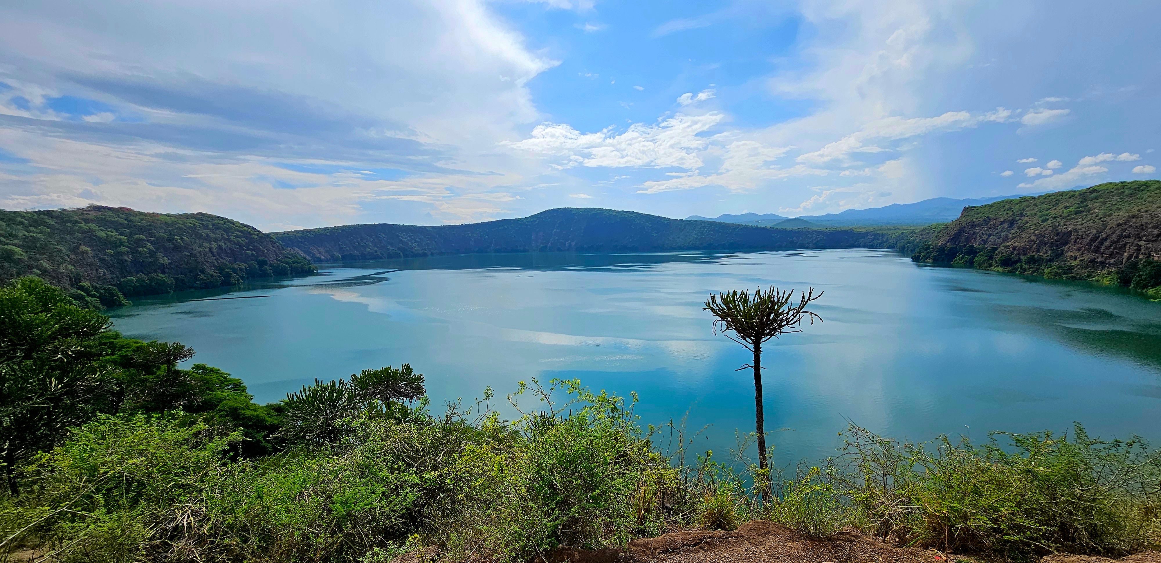
]]>Carol MusyokaThe Still Waters of Lake Chala2026-03-01T00:00:00+00:002026-03-01T00:00:00+00:00https://carolinemusyoka.github.io/the-still-waters-of-lake-chalaLake Chala sits in a volcanic crater on the border between Kenya and Tanzania, hidden from everything. You don’t stumble upon it, you have to seek it out. And when you finally reach the rim and look down, the colour of the water stops you cold. Turquoise so deep it almost looks unreal, surrounded by steep crater walls thick with vegetation.
The lake lies just east of Mount Kilimanjaro, though you wouldn’t know it until the clouds clear. The crater walls rise sharply around the water, thick with green vegetation that makes the lake feel sealed off from the rest of the landscape.
I came here on a detour from Taveta, following a dirt road that didn’t inspire much confidence. The road winds through dry bushland and scattered farms, and for a while it feels like you’re going nowhere. You’ll an old cement sign for the lake. A few metres up, a stop at the gate. to pay like 50 for the community. From the top the crater rim opens up and the lake appears below, the whole drive suddenly makes sense.
A Crater Lake Like No Other
What makes Chala special isn’t just the colour, it’s the stillness.
The lake sits inside an ancient volcanic crater believed to have formed roughly a quarter of a million years ago during the same volcanic activity that shaped the Kilimanjaro region. Over time the crater filled with water, creating the deep basin that exists today.
Unlike many lakes in East Africa, Chala has no rivers flowing into it. Most of the water arrives underground, filtering through volcanic rock from rainfall around Mount Kilimanjaro. Because of that natural filtration, the lake is remarkably clear, and its colour changes depending on the light, sometimes deep blue, sometimes bright turquoise, sometimes almost emerald.
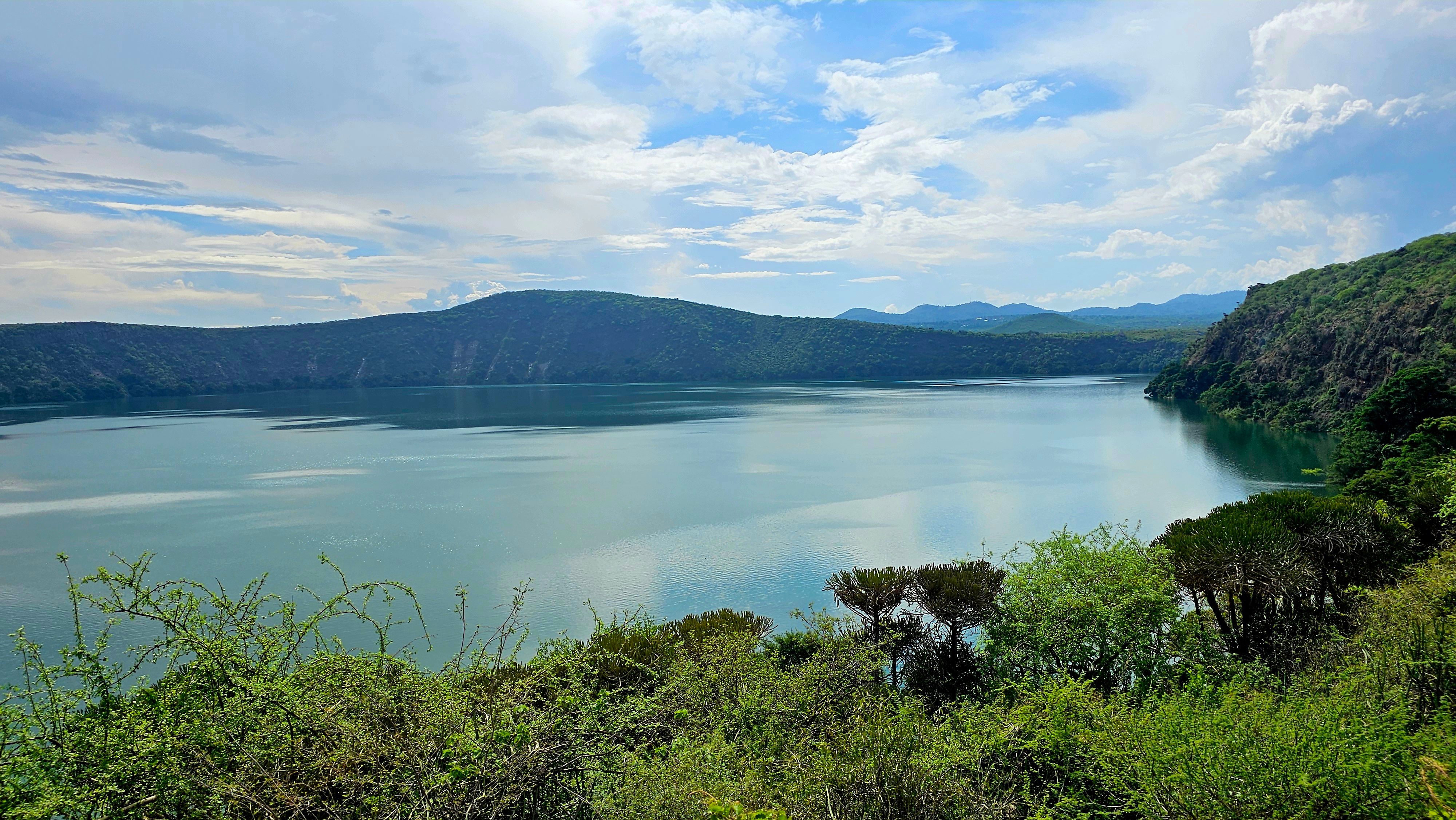
The lake itself is larger than it first appears from the rim. It covers roughly four square kilometres and drops to depths close to 100 metres in some places. Standing above it feels less like looking at a lake and more like peering into a giant natural bowl carved into the earth.
And despite all that scale, the place is incredibly quiet.
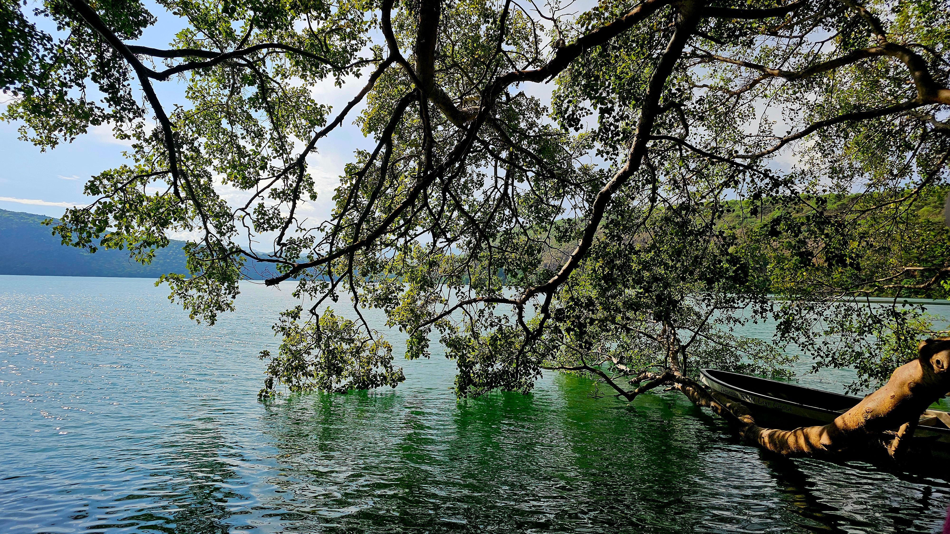
Getting Down to the Water
There’s a steepish trail from the rim down to the water’s edge. It takes less than ten minutes. Some loose rocks, thorny bushes, and a gradient that is quite manageable.
As you descend, the vegetation becomes thicker. The dry bush near the top gives way to greener patches closer to the water where the crater walls trap moisture and shade.
But at the bottom, you can swim in water so clear you can see the rocks many metres below. Don’t let that fool you though, the lake drops off quickly and is far deeper than it looks from the surface.
The locals will tell you there are crocodiles in the lake. Whether that’s true or just a long-standing story depends on who you ask. Some say crocodiles were introduced decades ago but never thrived in the steep crater environment.
Either way, when you’re standing beside water that deep and that quiet, you don’t feel like testing the theory.
The water was cool, impossibly clear, and the silence at the bottom of the crater was complete.
Some of the locals also offer to give you a boat ride on the lake. They say crossing it can take a full day all the way across, which sounds exaggerated at first, until you stand there and realise just how wide the crater actually is.
Life Around the Crater
Although the lake feels isolated, the surrounding area is part of the wider Kilimanjaro ecosystem. Wildlife still moves through the nearby bushland from time to time.
Baboons and vervet monkeys are common around the crater rim, and the area is known to have dik-diks and other small antelope. Birds are everywhere, fish eagles, kingfishers, and dozens of other species that thrive around the lake.
In fact, Lake Chala is known among birders as one of the quieter birdwatching spots in the region simply because so few people visit it.
The lake itself even hosts a rare species of tilapia found nowhere else in the world, a reminder of how isolated this crater ecosystem really is.
Stories the Lake Carries
Like many places that feel older than the maps drawn around them, Lake Chala comes with its share of stories.
Some local folklore says a village once existed where the lake now sits, swallowed when the crater collapsed long ago. Other versions say spirits still live in the water.
Whether those stories are meant literally or not, standing alone on the crater rim as the sun begins to set, it’s not hard to see why people imagined them.
There is something ancient about the place.
Something quiet.
Something that feels like it has been sitting there unchanged for a very long time.
Some places don’t need to be famous to be unforgettable.
If you’re in the Taveta area, don’t skip Lake Chala.
Bring water, wear proper shoes, and leave early — the morning light on the crater walls is extraordinary. When the sun hits the water just right, the lake turns a shade of turquoise that almost looks impossible.
]]>Carol MusyokaStanding on the Edge of the Rift2026-02-15T00:00:00+00:002026-02-15T00:00:00+00:00https://carolinemusyoka.github.io/the-rift-valley-escarpmentThere are viewpoints, and then there’s the Rift Valley Escarpment. The moment the road crests and the valley opens below you — vast, hazy, stretching to the horizon — is one of those scenes that makes you pull over whether you planned to or not.
I’ve driven this road more times than I can count, but I still stop every time. The scale of it never shrinks. The Great Rift Valley is one of the few geological features visible from space, and standing on the rim you understand why.
The View
From the escarpment edge, the valley floor drops nearly 600 metres. On clear mornings you can see Lake Naivasha glinting in the distance, the extinct volcanoes of Longonot and Suswa rising from the valley floor, and the far western wall of the rift barely visible through the haze.
The light changes everything here. Early morning gives you soft gold and long shadows across the valley. Midday flattens it into a heat shimmer. Late afternoon brings drama — storm clouds building over the western rim, shafts of light breaking through to spotlight patches of the valley floor.
The Drive Down
The escarpment road descends through a series of hairpin bends that drop you from highland cool into valley warmth in the space of fifteen minutes. It’s one of the most dramatic altitude changes on any road in East Africa. Roll down the windows — you can feel the air temperature shift as you descend.
Why I Keep Coming Back
Some landscapes are impressive once and then you’ve seen them. The Rift Valley isn’t like that. It changes with the seasons, with the weather, with the time of day. Every visit shows you something different.
The Rift Valley doesn’t reveal itself all at once. It asks you to keep looking.
If you’re driving from Nairobi to Naivasha or Nakuru, don’t treat the escarpment as a stretch of road to get through. Stop, look, breathe. This is one of the great views on the continent.
]]>Carol MusyokaKaruru Falls and the Aberdares2026-01-20T00:00:00+00:002026-01-20T00:00:00+00:00https://carolinemusyoka.github.io/karuru-falls-aberdaresThe plan was simple enough. Drive to the Aberdares, find the gate, get to the falls. It did not go that way.
We came in from the western side via Ndunyu Njeru — the route that takes you off the A104 after Soko Mjinga, through Thika Gatura road and then up the Ndunyu Njeru road toward Mutubio Gate. On paper it’s straightforward. On the ground, somewhere between the last tarmac and the park boundary, we got well and truly lost. The roads up here don’t forgive vague directions. There’s no signal, no signage worth trusting, and every murram fork looks like the right one until it isn’t. We doubled back twice before we found the right track.
One thing that helps: once you hit the Ndunyu Njeru junction, stay on the main road climbing uphill toward Kahuruko. The gate is after the descent on the far side — Mutubio Gate — where the tarmac reappears briefly before the park eats everything again. If you’re planning this drive, download offline maps before you leave Nairobi. Don’t rely on data up here.
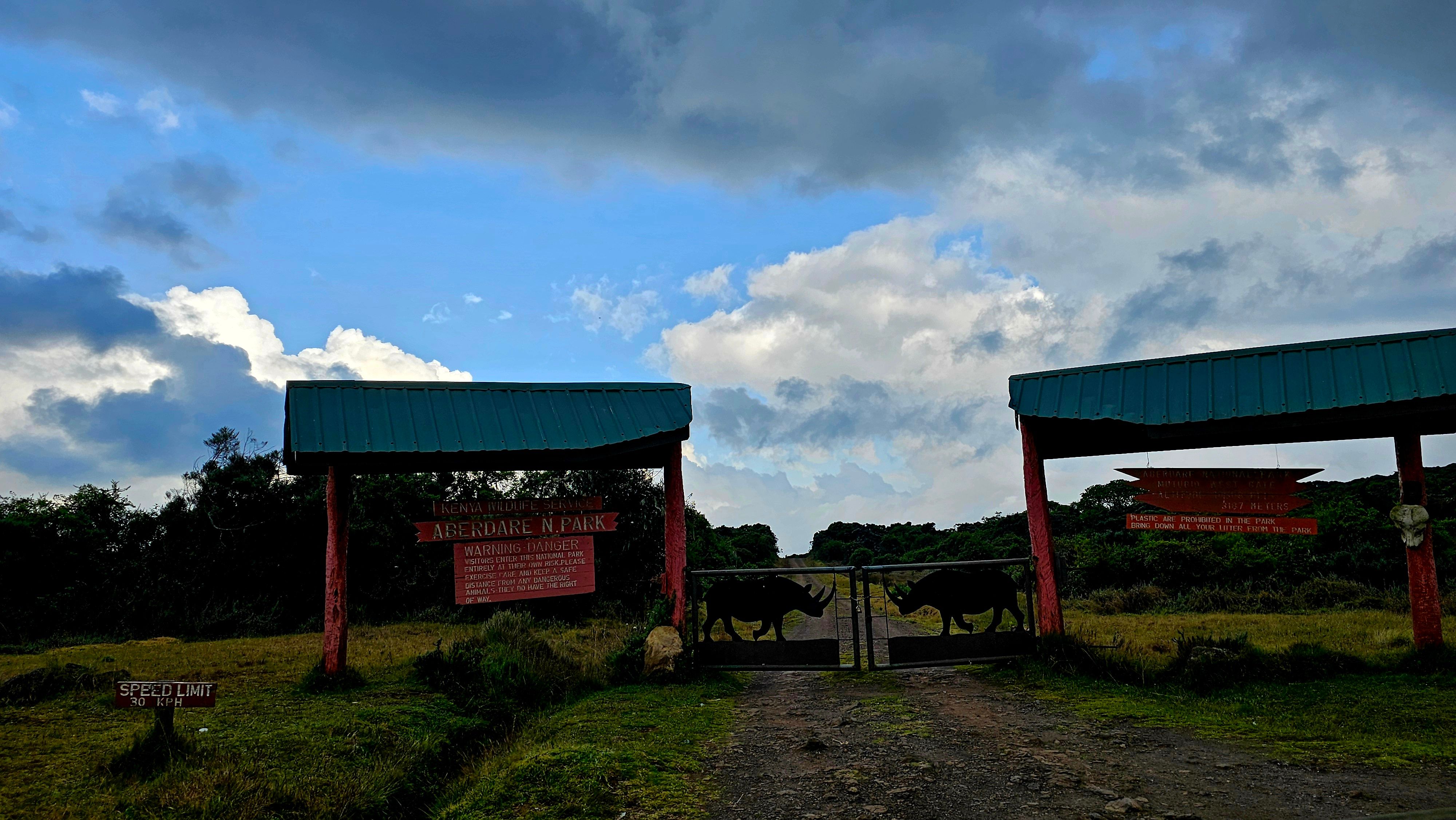
Mutubio Gate. After an hour of wrong turns, this felt like arriving somewhere.
Into the Park
At the gate you pay your KWS fees and get assigned an armed ranger guide, this is probably optional and it’s not just a formality. The rangers know where the animals are, know the tracks, and know when to stop the vehicle.
Payment is cashless through ecitizen, M-Pesa or card. There’s no ATM between Nairobi and here, you can also make payments online before leaving.
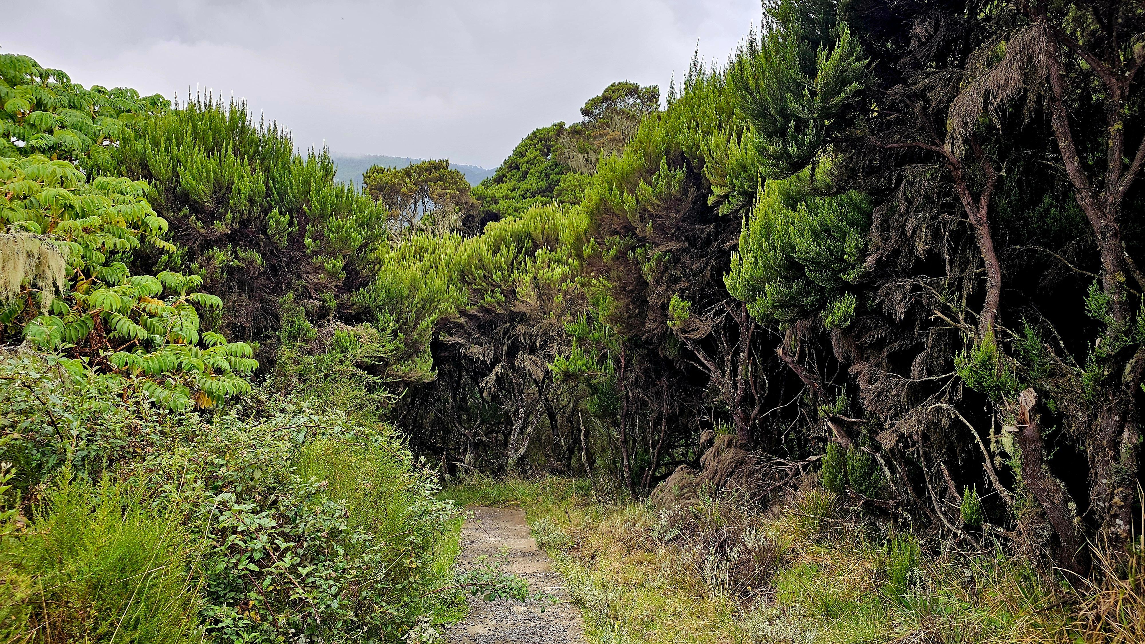
From Mutubio Gate, it’s 9 kilometres to the falls viewpoint. Not 9km on tarmac — 9km of park track, the kind that asks questions of your suspension and your ground clearance in roughly equal measure. A good 4WD handles it fine in dry conditions. In the rains, the same road is a different conversation entirely.
What You See on the Way
The 9km drive is the drive. Don’t rush it.
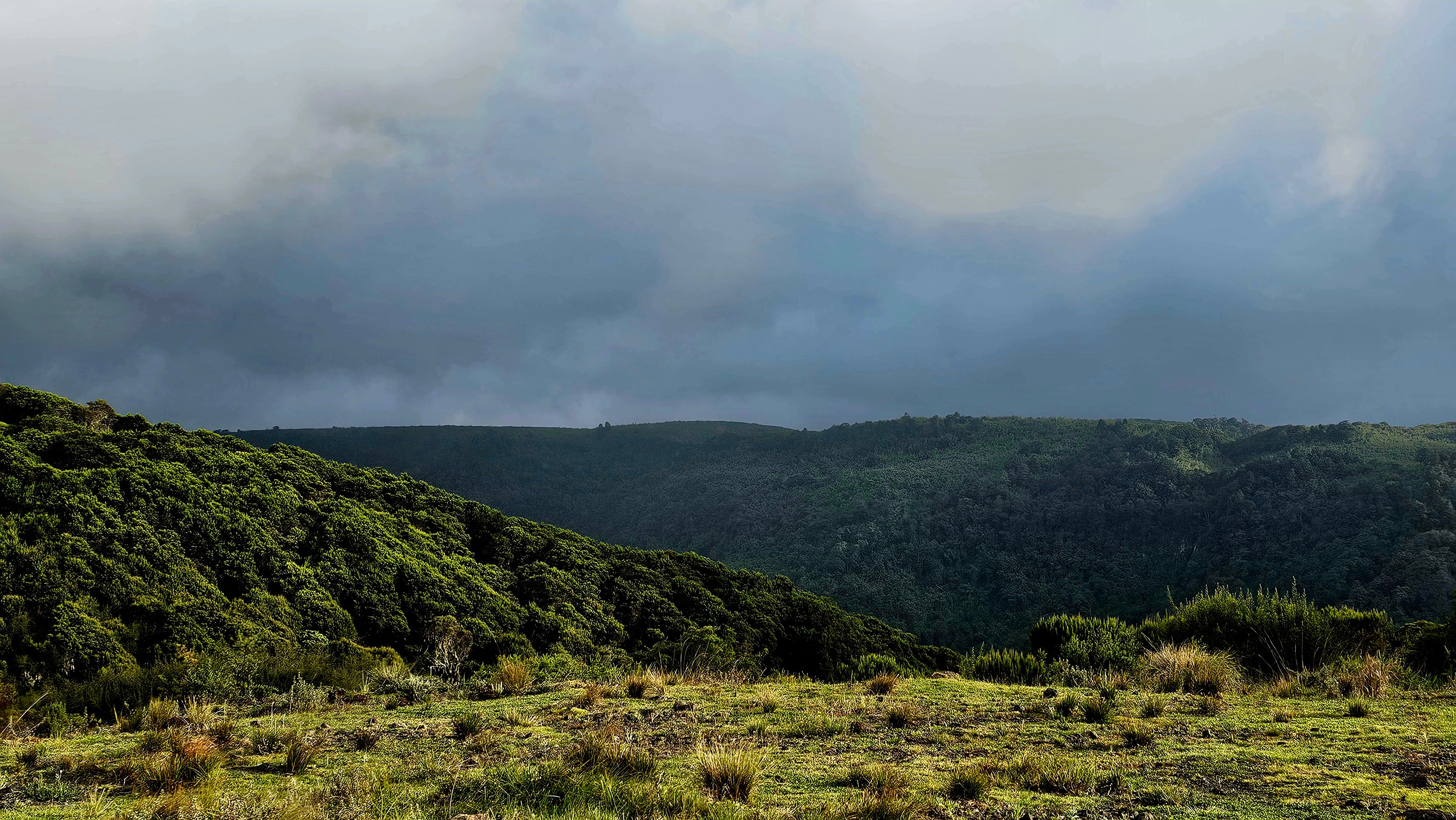
The forest closes in quickly after the gate — dense cedar and olive, the canopy blocking out the sky. Then the track opens onto moorland and the scale of the place becomes apparent. You’re treated to views of golden moorlands and cool forests filled with cedar trees. It looks like no other part of Kenya.
We stopped twice before we even reached the falls.
First for a herd of buffalo — a big group, maybe thirty animals, standing in the track with zero interest in moving. The guide told us to stay in the car and cut the engine. We sat for ten minutes while they finished whatever they were doing and eventually moved off into the undergrowth. There’s something about the weight of a buffalo herd that resets your sense of where you are. You stop thinking about the drive and start paying attention.
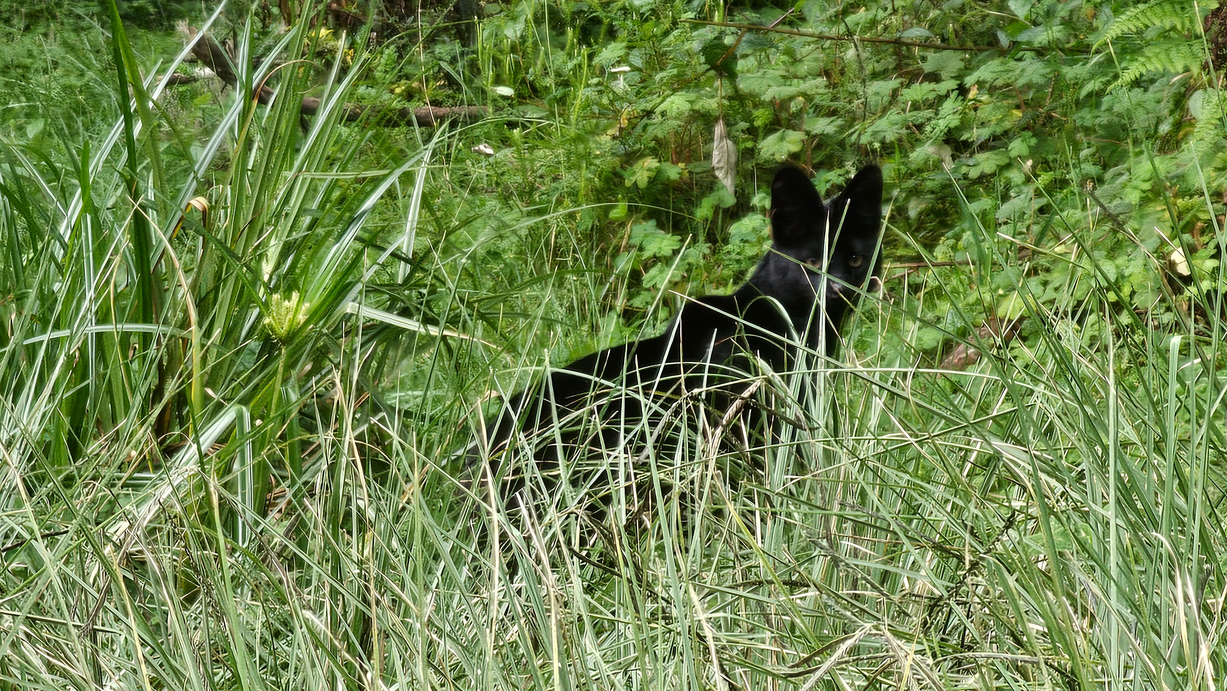
Then, a few kilometres further on, the guide touched my arm and pointed into the undergrowth at the edge of the track. An African wildcat — small, dark, crouched low in the grass — watching us from maybe eight metres away. It held its position for long enough to look back, then slipped into the forest. You don’t see them often. They’re nocturnal mostly and wary, and this one seemed almost offended at being noticed.
African wildcat. Held its ground for about thirty seconds, then vanished.
The Campsite
We passed the campsite on the drive in — a cleared area in the forest with basic facilities and a fire pit, and absolutely nothing else for kilometres in any direction. The kind of place that sounds very appealing at noon and slightly more complicated at midnight.
The campsite. Cold at night. Worth it.
If you’re serious about the Aberdares — and you should be — camping here means an early start for the falls with the mist still in the valley, which is the only way to see them properly.
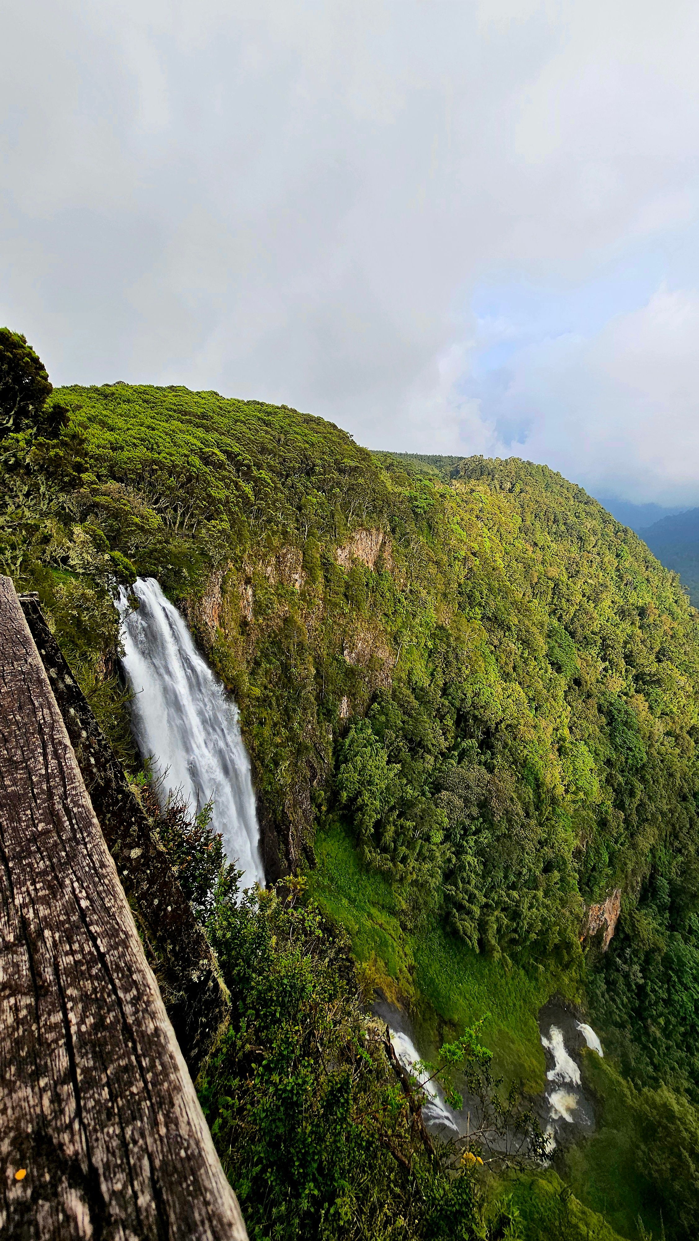
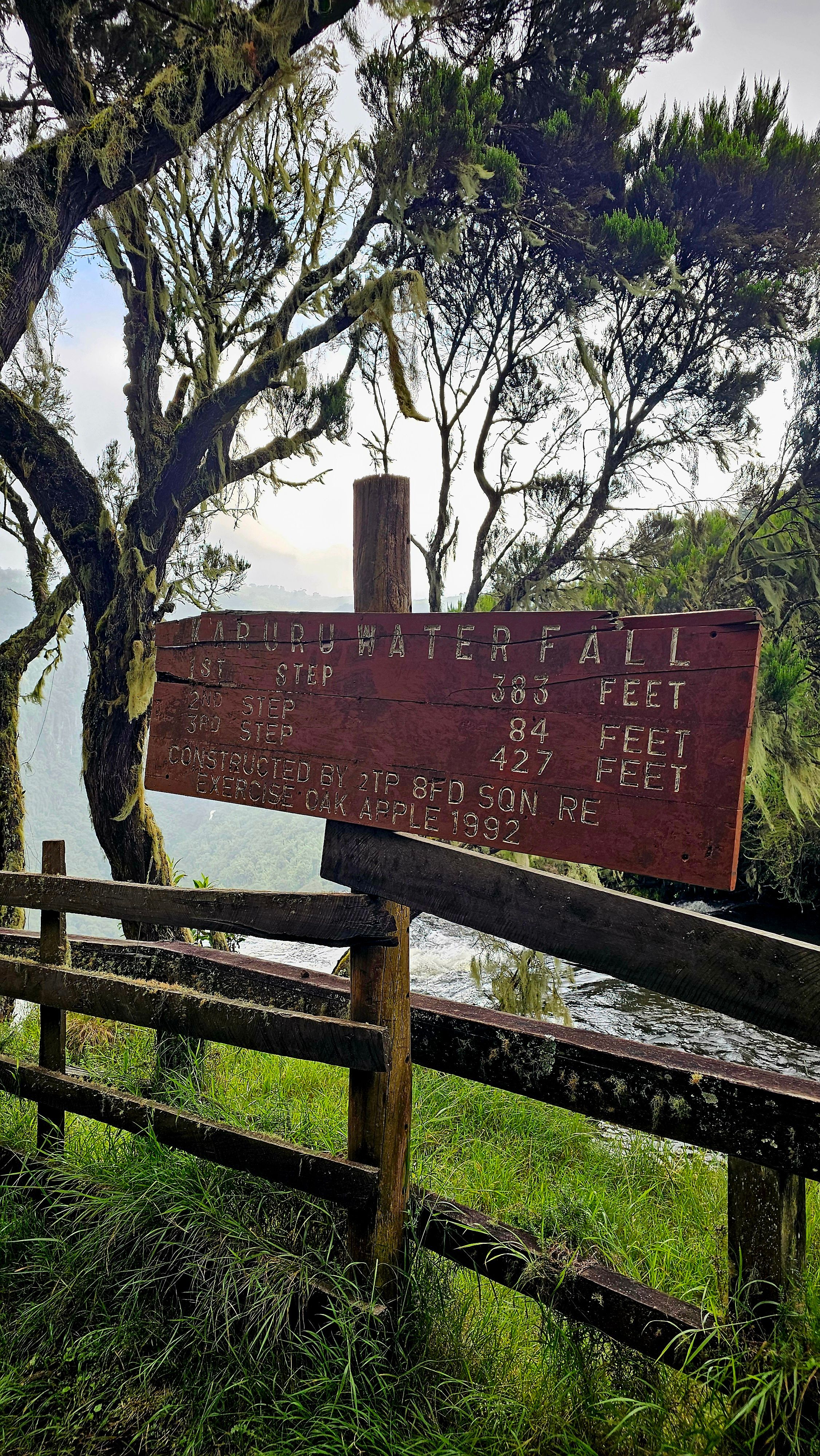
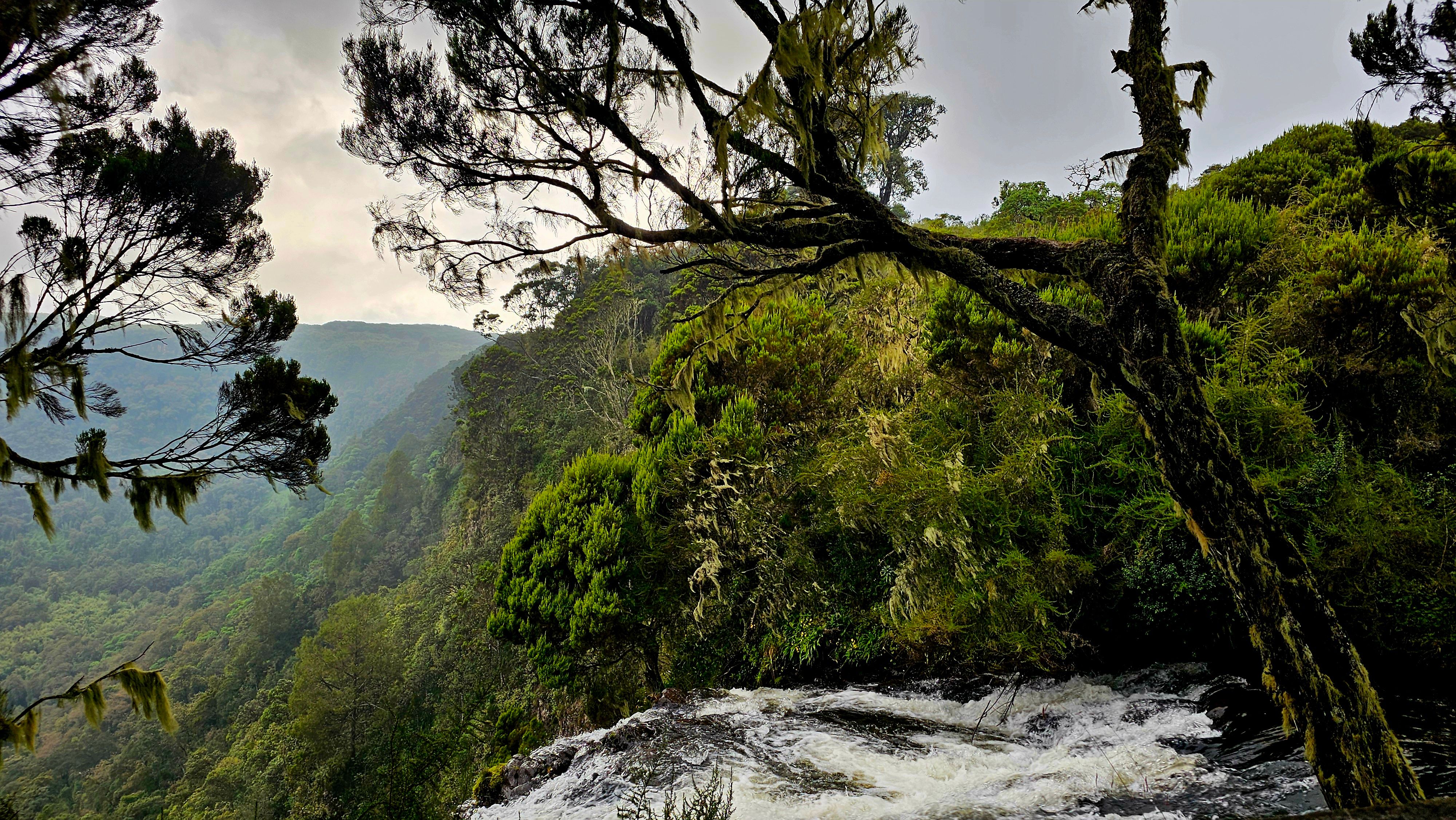
Karuru Falls
Karuru Falls has three tiers: the first at 117 metres, the second at 26 metres, and the third at 130 metres — totalling 273 metres, making it the highest waterfall in Kenya. Those numbers don’t mean much until you’re standing at the viewpoint and trying to trace where the water goes after the first drop. It disappears into forest and mist long before it reaches the bottom.
The first tier. The roar builds before you can see it.
You hear it before you see it. A low, sustained rumble that gets louder as the track approaches the gorge rim. Then the trees thin and the viewpoint opens and the whole thing is just there — a wall of white water dropping into a green gorge with mist rising back up out of it.
There are two viewing platforms. No hiking trails lead to the bottom of the falls for safety reasons — both falls stream into impenetrable ravines. You view from above, which is fine. The upper perspective is where the scale is most legible — you can see the first tier, the dense forest canopy far below, and on a clear day glimpse the second drop through the trees.
From the same viewpoint, Gura Falls is visible across the gorge. It doesn’t get its own signposting and most people don’t realise they’re seeing two waterfalls at once.
The Three Tiers
From the viewing point, you witness the powerful first drop, followed by the water weaving through the dense, pristine forest far below before crashing into the river. The second and third tiers are largely concealed by the canopy, appearing only as flashes of white through the trees when the wind moves the branches.
It’s cold here. The Aberdares sit above 3,000 metres and the gorge generates its own microclimate — the mist coming off the falls chills everything within range. Bring a layer you don’t mind getting damp.
What I’d Do Differently
Go earlier. We arrived in the early afternoon, which meant the mist had mostly lifted and the light was flat. The falls face east and catch morning light, if you camp at the park campsite or start from Nairobi before 6am, you have a chance at the mist-and-golden-hour combination that makes the Aberdares photographs you actually want.
If you camp give yourself two days. The park has four waterfalls — Karuru, Gura (viewable from Karuru), Chania, and Magura. Chania has three viewing platforms, each lower than the other, making it a hike all the way to the bottom — the most beautiful of them all. We didn’t make it to Chania. That’s unfinished business.
The Aberdares also host the second-largest population of the endangered black rhino in Kenya, and large herds of forest buffalo and elephants are frequent visitors. We got the buffalo. The rhino remains on the list.
The Aberdares remind you that Kenya isn’t just savannah and beaches. Some of its most powerful landscapes are hidden in the highlands, behind bad roads and no signal and a lot of wrong turns.
Bring layers. Bring rain gear. Download your maps offline. And if you get lost on the Ndunyu Njeru road — you’re probably not far from the gate. Keep looking.


.jpg)